Manchester Area Historical Society
Research on River Bend Gardens Properties
River Bend Drive, Manchester, Michigan
Information Gathered for Wayne Oliver
February 1, 2020
1. The subject properties include the following seven parcels, located in the Village of Manchester and Manchester Township, west and north of current Riverbend Drive. Sections 2 and 3 of Manchester Township.
- PM-16-02-265-054 – N 1/4 COR SEC 2, TH S 00-00-43 W 1686.15 FT, TH S 89-43-36 W 536.97 FT TO A POB, TH S 00-16-24 E 181.43 FT, TH S 31-33-12 W 276.44 FT, TH S 89-43-36 W 659.25 FT, TH N 00-03-35 W 416.31 FT, TH N 89-43-36 E 803.48 FT TO THE POB. PT OF BLK 15 J W COWANS 2ND ADD & PT OF NW 1/4 SEC 2, T4S-R3E. 7.29 AC.
- PM-16-02-265-002 – E 1/2 OF SW 1/4 OF NW FRL 1/4 SEC. 2 T4S R3E 14.15 AC
- PM-16-02-265-003 – COM AT NW COR SEC 2, TH S 00-14-00 E 1703.70 FT ALNGW LN SEC TO POB, TH N 89-37-55 E 689.45 FT, TH S 00-38-00 E 315.75 FT, TH WEST 691.66 FT, TH N 00-14-00 W 311.28 FT TO POB. PT OF NW 1/4 SEC 2, T4S-R3E. 4.97 AC.
- PM-16-02-265-004 – S 3/4 OF W 1/2 OF SW 1/4 OF NW FRL 1/4 EXC 1.10 AC IN SWCOR, SAID 1.10 AC DESC AS BEG AT W 1/4 POST OF SEC, THN 290 FT IN W LINE OF SEC TO THE CENT OF RIVER RAISIN,TH E’LY & S’LY ALONG THE RIVER TO A POINT IN THE E & W 1/4 LINE, TH W 163 FT IN THE E & W 1/4 LINE TO THE PLOF BEG. 2 T4S R3E 13.90 AC.
- P-16-02-200-009 – COM AT N 1/4 POST OF SEC, THW 20.26 CHNS IN THE N LINE OF SEC, TH S 19.45 CHNS FOR A PL OF BEG, TH S 398.95 FT,TH W 631.40 FT IN THE S LINE OF N FRL 1/2 OF NW FRL 1/4, TH N 403.60 FT, TH E’LY636.34 FT TO THE PL OF BEG, BEING A PART OF N FRL 1/2 OF NW FRL 1/4 SEC.2 T4S R3E 5.85 AC.
- P-16-02-200-010 – COM AT N 1/4 COR OF SEC 2, TH S 0-0-43 W 1686.38 FT, TH S 89-43-36 W 894.98 FT TO POB, TH N 0-0-43 E 392.94 FT, TH N 89-30-9 W 446.45 FT, TH S 0-2-30 E 398.95 FT, TH N 89-43-36 E 446.07 FT TO POB PART NW 1/4 SEC 2 T4S R3E 4.06 AC
- P-16-03-100-005 – BEG AT THE NE COR OF THE S 1/2 OF NE FRL 1/4, TH W 715 FT IN THE N LINE OF S 1/2 OFNE FRL 1/4 TO THE CENT OF THE RIVER RAISIN TH SE’LY ALONG THE RIVER RAISIN TO A POINT IN THE E LINE OF THE SEC, TH N 3 DEG 22′ W 1036 FT IN THE E LINE OF THE SEC TO THE PL OF BEG, BEING THATPART OF S 1/2 OF NE FRL 1/4 LYING E OF THE RIVER SEC 3. T4S-R3E 9.00 AC
2. An aerial photograph provided by Wayne Oliver (shown on Page 15) shows the parcel alignment relative to the current Riverbend subdivision and the River Raisin in Manchester. A map provided by Washtenaw County Parks and Recreation shows the contour elevations and wetland locations for these parcels.
3. The Washtenaw County MapWashtenaw application provides the current aerial photograph of the parcels, along with the location of the section line between Sections 2 and 3 of Manchester Township, which is the closest section line to these parcels. This is shown as Figure 1 below.

4. Wayne Oliver is seeking information on the original vegetation, flora and fauna, and tree types/openings for these properties prior to original development of the general Manchester area, circa 1833. He is also interested in the presence of wet prairies/springs in these areas. This information has been assembled in this document from the following primary sources:
- Surveyor notes and maps from the original township surveys, conducted to establish formation of the townships. For Manchester Township, designated as Township 4S, Range 3E relative to the baseline and meridian lines established by the Territory of Michigan, these surveys took place in 1815 (township border line survey by Benjamin Hough) and 1824 (full township survey with section lines defined, by John M. Mack in 1824).
- Portrayal of Washtenaw County 1800 Vegetation through interpretation of accumulated township survey information, taken from original township survey data, as assembled by the Michigan Department of Natural Resources and MSU Extension in 1997 in the Michigan Natural Features Inventory project.
- Examination of the 1839 Douglass Houghton Washtenaw County Survey Map, and the 1845 Samuel Pettibone Washtenaw County Survey Map.
- Review of the 1856, 1864, 1874 and 1915 Manchester Township Plat Maps.
- Review of 1940 Aerial Photograph of the subject properties.
- Review of other miscellaneous sources, including maps of Native American trails, and Orange Risdon’s survey map of 1827.
- Current aerial photograph, and WCPARC map of contours and wetlands.
5. The first full township survey defining the sections in Manchester Township (T4S, R3E) took place in February 1824, and was conducted by John M. Mack of Pontiac, along with Hosey Harris and Oliver Parker, under contract from the US Government Land Office. They were tasked with surveying and staking the individual section corners and lines, and recording key information on what they observed along these section lines, including significant tree and soil types, water flow, salt springs and unusual features. A township map of the surveyed section lines and corners was produced, and information was also recorded in a small notebook by Mack. Both the original map and notebook have survived, and are in the State of Michigan archives. The map and notebook have been scanned, and are available for viewing and downloading at the Michiganology website.
The following link will connect with these resources: https://michiganology.org/?s=Manchester+surveyor
The full 1824 township map is shown as Figure 3.
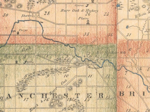
From the legal descriptions of the land parcels, the River Bend Gardens land parcels are primarily in the northwest ¼ (NW1/4) of Section 2 of the township, with a small portion of one parcel in the northeast ¼ (NE ¼) of Section 3. An excerpt of the Mack map as produced in 1824, focusing on the Section 2/3 border line, is shown in Figure 2 below:

It is important to note that the surveyors only walked along the section lines (north and south, and east and west), and did not walk within the sections. So what they recorded is what was viewable from the section lines as they staked and moved their surveying chain along. From this excerpt, we see only the River Raisin marked as flowing across the section lines, and some wetlands existing on the north side of Section 2. There are no further markings of vegetation types on this map. It was very important that on the southeast corner of Section 2, they recorded the significant water drop and hydraulic potential of the river at this site, with the notation of “a good mill seat”. This notation was subsequently used by John Gilbert in selecting this as the future site of the Village of Manchester, purchasing the site in 1826, and then founding the town here in 1833.
To get further details on what John Mack and his crew observed, we turn to the field notebook, where each page is covering the surveying of a one-mile line between two sections. We examined the page that would cover the section line running north and south between Sections 2 and 3, as this was the closest to the future River Bend Garden parcels the surveyors would approach, running through them at one point, and otherwise providing the best visibility of these parcels as they existed in 1824.
Mack’s notes on surveying the section line between Sections 2 and 3 are noted on the page entitled:
IntLinesVol20_12, File Number 91337.jp2, on the Michiganology web link provided above.
The full page is reproduced as Figure 4 below. The key findings noted on this page are:
- The presence of extensive white oak trees on the section line between Sections 2 and 3. The trees both sat on the section line, or served as “reference markers” for the placement of stakes.
- The presence of the river crossing the section line, 62 links wide, with significant current flow.
- This information confirms the presence of oak openings, and, from the map notation, the headwaters of a wetlands area.
We also briefly examined the earlier 1816 Benjamin Hough survey notes, when Hough and crew marked off the four corners of several townships in Washtenaw and Lenawee Counties, including Manchester Township, but did not do any internal surveys. These notes contain detailed surveying and marker location information, but no vegetation or natural elements information, and could not be easily related to actual field locations today. So, no useful information was obtained from these Hough records.
6. In 1997, the Michigan Department of Natural Resources and MSU Extension undertook a project to translate all the surveyor vegetation and natural resources information contained in the original township surveys into a map entitled “Portrayal of Washtenaw County 1800 Vegetation”, through interpretation of accumulated township survey information, as taken from original township survey data. This project was entitled “Michigan Natural Features Inventory”, and the website for this program is https://mnfi.anr.msu.edu/
This project resulted in the creation of a county wide map showing the vegetation existing circa 1800 throughout Washtenaw County. The full map with legend is shown as Figure 6 below. The excerpt showing the River Bend Gardens area is shown as Figure 5 with legend below. This excerpt map shows extensive mixed oak forests, a thin band of mixed hardwood swamps, and a large black oak barren area, aligned with the contours of the area.


7. Douglass Houghton and Samuel Pettibone Survey Maps
The original survey conducted by John M. Mack in 1824 was followed up by two county wide surveys. In 1839-1845, Douglass Houghton, Surveyor for the State of Michigan, undertook extensive surveys across the state, with work being done in Washtenaw County in 1839. The segment from his 1839 map showing Sections 2 and 3 in Manchester Township is shown in Figure 7 below:

While there are no notes written explicitly in Sections 2 and 3, likely due to map congestion in this area, nearby notes indicated “Heavily Timbered” and a “Rolling” terrain.
Samuel Pettibone conducted his own survey of Washtenaw County in 1843, and Figure 8 shows the closeup of Sections 2 and 3 in Manchester Township. While again there is no writing in the explicit area of study, Pettibone’s notes indicate the general presence of white oak, burr oak and hickory plains as existing in this area.
Original Ownership of Land and Manchester Township Plat Maps (1856, 1864, 1874, 1915)
The northwest ¼ of Section 2 was first acquired by Abraham Delamater on April 4, 1833 from the U. S. General Land Office in Monroe. He owned the property into the 1840s, but sold to John Kief et al and moved to Jackson County where he founded the town of Brooklyn, Michigan. There is no evidence he developed anything on this parcel.
There are four Manchester Township plat maps often used for early research on land ownership and usage. The 1856 plat map is the earliest produced, and is considered highly accurate in land plats and other information.
The excerpt from the 1856 Manchester Township plat map is shown in Figure 9. This diagram shows that all the current River Bend Gardens lands were held as investment properties by brothers John D. Kief and Lucian B. Kief, John D. Corey, and John W. Cowan. These men were heavily involved in land investments prior to the Civil War, and there is no evidence that any of them were involved in farming or other agricultural uses of the lands.

The 1864 Plat Map shows the same owners and same lack of development. Figure 10 below shows the 1874 ownership, still dominated by J. D. Corey and J. W. Cowan, but the Riverbend subdivision has been platted and farms/homes are developing along the north end of Section 2. By 1915, the properties have been sold to various owners, but there is no sign of home development. See Figure 11.
9. Review of Other Sources
The properties were reviewed for Native American trail history, and the north side of the River Raisin through Sections 2 and 3 was a major trail route for Native Americans, where different tribes used the north and south side of the river for their own routes. The image below was created in 1928 by George Wahr.

We also reviewed surveyor Orange Risdon’s 1827 survey of lands west of Detroit, centered along the Chicago Road (US-12, Michigan Avenue). While his map showed individual townships, rivers/lakes, and land parcels which had been sold to date, it has no further information such as vegetation, topography or other features.
10. 1940 Aerial Survey of Manchester Township
Aerial photographs of Washtenaw County exist back to 1940. The corresponding image to the 2019 photo shown in Figure 1 for the properties under study, is shown as Figure 13 below.


Download: MAHS Research of River Bend Gardens Properties – February 2020
